Climbs: elevation profile and climb screen¶
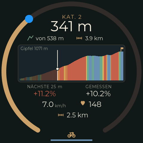
When TrailBridge plays a GPX route, it sends the elevation profile of the next climb
(protocol, "elevation
profile service"). The bike computer finds foot and summit in it, rates the climb and
shows it on the screen RimRidgeClimb (design, §6).
| Part | File |
|---|---|
| Wire format | src/BikeProfileProtocol.h |
| Algorithm (pure, host test) | src/ClimbProfile.*, test/native_climb/climb_test.cpp |
| Integration: BLE, position, settings, CLI, web, demo | src/ClimbMonitor.*, BLEDevices::subscribeProfile() |
| Screen | src/ui/RimRidgeClimbCustFunc.*, UIFacade::updateClimb() |
What the phone sends, and what the firmware does with it¶
TrailBridge sends the climb ahead: the altitudes from the current position to the
summit, as soon as the foot is at most 500 m away -- in one frame. Up to 5 km on a 25 m
raster, coarser for longer climbs (up to 250 m; the 36 km Galibier from the south comes
with 200 m). PROFILE_NONE follows at the summit. Small hills (from 10 m of altitude
gain) are sent as well.
The firmware
- finds the climb: the foot is the first point from which the next 100 m rise by 3 %
on average. The summit is the last point before a descent of more than 30 m or before
2 km without an average gradient of 0.5 % -- or the end of the profile. A shorter flat
section or a dip does not end the climb; the Galibier from the north is two climbs
(descent from the Télégraphe to Valloire). TrailBridge searches with the same criteria
(
ElevationProfile.javathere) -- the defaults of both sides belong together. - joins frames (same raster, overlapping) and keeps the part already ridden, up to 320 steps. This is only needed when a climb does not fit into one frame even on the 250 m raster.
- continues a climb when the phone sends
PROFILE_NONEand a new profile shortly after. - knows the position from the remaining distance in the navigation frames, advanced between two frames by the distance from the speed sensor.
Altitude figures are net: summit minus foot, summit minus rider.
Categories¶
Score = length [m] × average gradient [%] = 100 × altitude gain. This is the scale of Strava and Garmin (ClimbPro) for 4 to HC; 5 and 6 continue it downwards by halving.
| Category | Score from | Altitude gain from | Example |
|---|---|---|---|
| 6 | 2 000 | 20 m | 400 m at 5 % |
| 5 | 4 000 | 40 m | 800 m at 5 % |
| 4 | 8 000 | 80 m | 1.6 km at 5 % |
| 3 | 16 000 | 160 m | 3 km at 5.5 % |
| 2 | 32 000 | 320 m | 5 km at 6.5 % |
| 1 | 64 000 | 640 m | 9 km at 7.5 % |
| HC | 80 000 | 800 m | 10 km at 8 % |
Not rated (short hill, no automatic display): shorter than 300 m, flatter than 3 % on average, or less than 20 m of altitude gain.
Display¶
- The screen appears by itself as soon as a rated climb is at most 300 m ahead, and returns to the main screen 5 s after its end. It only replaces the main screen; if navigation, road labels or settings are showing, it becomes the target of "back".
- By hand: a tap on altitude or gradient on the main screen opens it, a swipe closes it. A climb that was swiped away does not come back by itself.
- Profile colour by the gradient of the raster section (25 m, up to 250 m for long climbs): below 1 % blue, up to 4 % green, up to 7 % yellow, up to 10 % orange, red above. The part already ridden is dimmed.
Settings¶
Every value can be set individually and is stored in NVS (Climb):
climb                     state and all settings
climb cat4 9000           set
climb cat4                show (with range and meaning)
climb defaults            default values
Without USB: /debug/climb (table with input fields), /debug/climb.json,
/debug/climb/set?<name>=<value>.
| Name | Default | Meaning |
|---|---|---|
startgrade / startwindow |
3 % / 100 m | foot: average gradient over this distance |
contgrade |
0.5 % | average gradient from the summit so far with which the climb continues |
summitflat |
2000 m | flat section that ends the climb; also the distance within which a new climb continues the old one |
summitdip |
30 m | descent that ends the climb |
summitpass |
50 m | this far behind the summit the climb is over |
minlength / mingrade |
300 m / 3 % | not rated below |
cat6 … cat1, cathc |
see above | score per category |
autoshow |
1 | switch to the climb screen automatically |
autorank |
1 | from which rank: 1 = category 6 … 6 = category 1, 7 = HC |
showahead |
300 m | distance to the foot at which the screen appears |
hidedelay |
5 s | wait before switching back |
lookahead |
25 m | distance for the "gradient ahead" |
band1 … band4 |
1 / 4 / 7 / 10 % | limits of the profile colours |
infocycle |
4 s | cycle of the info field (time, distance, temperature, cadence, altitude) |
Trying it without a phone¶
climb demo                2 km at 6 % (default)
climb demo 4000 9         length in m, average gradient in %
climb pos 800             put the rider 800 m behind the start of the profile
climb show / climb hide   open / close the screen
climb demo off
The demo profile runs through the parser as a normal frame. The rider moves with the
speed sensor (in the simulator build with sim <km/h>) or by climb pos. Frames from
the phone are ignored meanwhile.
Limits¶
- Only with a GPX route with altitude data played in TrailBridge. There is no profile with OsmAnd navigation.
- Climbs longer than 5 km come on a coarser raster (up to 250 m); "gradient ahead" and the profile colours then average over such a section.
- Above 50 km (or with a small MTU) the climb does not fit into one frame. The end of the profile then counts as a provisional summit until the next piece arrives.
- Values for
contgrade,summitflatandsummitdipstored in NVS take precedence over new defaults (climb defaultsresets them). - If the bike computer connects in the middle of a climb, the climb counts from there.